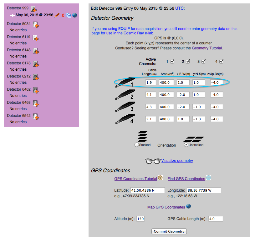
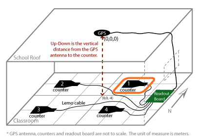
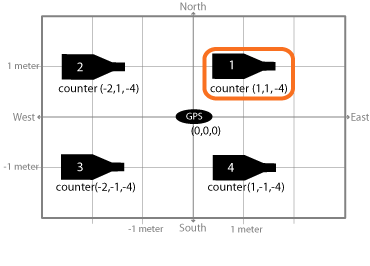
Compare the values in the screen shot below to the diagram above.
We have circled Counter 1 and its values to help you.
The geometry update page consists of three main areas: Detectory List in the purple box on the side, Detector Geometry,
and GPS Coordinates.
This display is set up in an "unstacked", or "array", orientation. If your counters are set up
in a "stacked" orientation, you should make sure that you accurately measure
the altitude (Up-Dn) of each indivual counter instead of assuming that they're
all at the same altitude. Some of our analyses need to know the order in which
the counters are stacked.
Once all of the information is entered, click "Commit Geometry" to write that
information to a file that will be used in future analyses.
Please check that your Date/Time values are all selected.
-
Meaning: You did not enter a value for all 5 fields of Date and
Time (Month, Day, Year, Hour, Minute). All 5 fields of the Date and
Time need to be selected to provide the date for which your geometry
changed. If you linked to the geometry page from the "Upload Successful!"
page, make sure the date you enter is BEFORE the start of that data run.
-
Fix: Choose a valid value in each pulldown box (valid meaning not
"Month", "Day", "Year", "Hour", "Minute").
Date cannot exceed current date.
-
Meaning: You entered a Date and Time that is past the current Date
and Time. You cannot make a geometry entry for the future. Remember,
the Date and Time you enter must be the Date and Time in
UTC, not your local Date and Time.
-
Fix: Choose values for each pulldown box that corresponds to a Date
and Time that is not past the current Date and Time.
Date exactly matches that of an existing geometry entry.
-
Meaning: You entered a Date and Time that exactly matches the Date
and Time of another geometry entry. If you want to edit that geometry entry,
you must click on the "edit" pencil next to that entry.
-
Fix: Choose values for each pulldown box that do not create a Date and
Time identical to that of another geometry entry.
Please check that your channel 1 Cable Length value is correct.
Please check that your channel 2 Cable Length value is correct.
Please check that your channel 3 Cable Length value is correct.
Please check that your channel 4 Cable Length value is correct.
-
Meaning: You entered an invalid value for the given channel's (1, 2, 3, 4)
cable length. The cable length input will only accept positive numbers
(integers, decimal numbers).
-
Fix: Enter a positive number.
Please check that your channel 1 Area value is correct.
Please check that your channel 1 E-W value is correct.
Please check that your channel 1 N-S value is correct.
Please check that your channel 1 Up-Dn value is correct.
Please check that your channel 2 Area value is correct.
Please check that your channel 2 E-W value is correct.
Please check that your channel 2 N-S value is correct.
Please check that your channel 2 Up-Dn value is correct.
Please check that your channel 3 Area value is correct.
Please check that your channel 3 E-W value is correct.
Please check that your channel 3 N-S value is correct.
Please check that your channel 3 Up-Dn value is correct.
Please check that your channel 4 Area value is correct.
Please check that your channel 4 E-W value is correct.
Please check that your channel 4 N-S value is correct.
Please check that your channel 4 Up-Dn value is correct.
-
Meaning: You entered an invalid value for the given channel's
(1, 2, 3, 4) specified field (Area, E-W, N-S, Up-Dn). These fields will
only accept numbers (integers, decimal numbers, and negative numbers).
Area will not accept negative numbers. To specify directions in the
E-W, N-S, and Up-Dn fields, use positive (E, N, Up) and negative
(W, S, Dn) numbers.
-
Fix: Enter a number (positive for Area).
With stacked orientation, the E-W values for all four channels should be equal.
-
Meaning: You indicated that your counters are stacked, but you
also indicated that your counters have different E-W offsets from the
GPS unit. If your counters really are stacked, then they should
all have the exact same E-W offset from the GPS unit.
-
Fix: Either change your orientation from "Stacked" to "Unstacked"
or give every channel's E-W field the same value.
With stacked orientation, the N-S values for all four channels should be equal.
-
Meaning: You indicated that your counters are stacked, but you
also indicated that your counters have different N-S offsets from the
GPS unit. If your counters really are stacked, then they
should all have the exact same N-S offset from the GPS unit.
-
Fix: Either change your orientation from "Stacked" to "Unstacked"
or give every channel's N-S field the same value.
With stacked orientation, the Up-Dn values for all four channels should be different
-
Meaning: You indicated that your counters are stacked, but you
also indicated that your counters have the same Up-Dn offsets from the
GPS unit. If your counters really are stacked, then they should
all have a different Up-Dn offset from the GPS unit. This is important
because in some studies looking at stacked counters, we need to know
the order in which the counters were stacked, and we get that
information from the Up-Dn offsets that you put into the geometry entry.
-
Fix: Either change your orientation from "Stacked" to "Unstacked"
or give every channel's Up-Dn field a different value.
Please check that your Latitude value is correct.
-
Meaning: You entered an incorrectly-formatted value for the
latitude of your GPS unit. The format must look like: 47:39.2347.
-
Fix: Enter a correctly-formatted latitude value
Please check that your Longitude value is correct.
-
Meaning: You entered an incorrectly-formatted value for the
longitude of your GPS unit. The format must look like: 122:18.68 W.
-
Fix: Enter a correctly-formatted longitude value
Please check that your Altitude value is correct.
-
Meaning: You entered an invalid value for the altitude of the
GPS unit. This field will only accept positive numbers (integers,
decimal numbers).
-
Fix: Enter a positive number.
Please check that your GPS Cable Length value is correct.
-
Meaning: You entered an invalid value for the cable length
connecting the GPS unit to the DAQ board. This field will only accept
positive numbers (integers, decimal numbers).
-
Fix: Enter a positive number.

 ),
delete (click
),
delete (click  ), duplicate (click
  ),
or view map (click
),
or view map (click  ),
as well as add new ones for each detector (click
),
as well as add new ones for each detector (click  ).
). ) or spread out
(
) or spread out
( ).
).